The UAV Survey and Mapping industry continues to expand rapidly, with new developments announced regularly. A 2018 Skylogic Research report identified survey and mapping as the second largest application of drone technology, only aerial photography/video capture were reported as having a larger UAV market share. With this growing market and a desire to control expenses, UAV surveyors are seeking to simplify their logistics, such as eliminating the need for GNSS reference stations or to establish survey ground control points. Essentially, the UAV survey and mapping community are actively seeking new survey operation techniques and solutions that are more automated, require minimal interaction, and are, above all, cost effective.
One such solution to this need is the use of Continuous Operating Reference Stations (CORS).
The Drawback of Continuous Operating Reference Stations (CORS)
The data from the CORS can be used for single base station processing or processed in a network solution to produce a moving Virtual Reference Station or VRS, which enables high-accuracy carrier-phase differential GNSS positioning anywhere within the network (the Applanix POSPac SmartBase module is an example of such a solution). The advantage of this approach is that no GNSS reference station hardware is required; however it can take up to 24 hours for the CORS data to be available for data processing, which delays the generation of final mapping results.
Solving GNSS Errors with Precise Point Positioning (PPP) and Trimble RTX
An alternative to establishing physical reference stations or using an existing network of CORS for differential GNSS processing is the Precise Point Positioning (PPP) technique. Instead of differencing the rover observables from the reference station observables and cancelling out atmospheric and satellite errors, an advanced model for every aspect of the GNSS error chain is developed and parameterized. The Trimble CenterPoint® RTX™ PP-technology combines the methodology of PPP with advanced ambiguity resolution technology to produce centimeter-level positional accuracies anywhere on the globe.
Trimble RTX leverages real-time satellite and atmospheric data from a global network of tracking stations, along with highly accurate models and algorithms to generate Trimble RTX corrections. These corrections are then broadcast to the receiver via a set of geostationary satellites or over the Internet, which the receiver uses to improve the accuracy of its GNSS positions.
The figure below illustrates how the Trimble RTX positioning works.
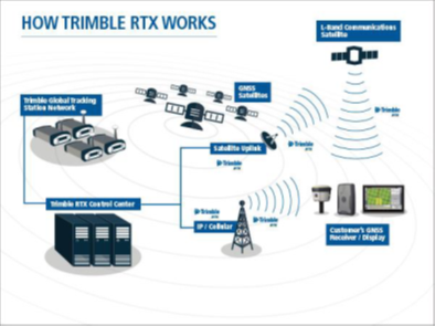
This breakthrough technology provides high accuracy, real-time GNSS positioning virtually anywhere on Earth, without the use of traditional reference station-based differential RTK infrastructure.
Harnessing RTX for Fast, Exacting Post-Processed Accuracies
Applanix has combined its POSPac post-processing software with the Trimble RTX technology to create a Post-Processed CenterPoint® RTX™ service (PP-RTX) that generates a post-processed position and orientation solution accurate to the centimeter level, minutes after data collection. The service is available via an internet connection, eliminating the need for base stations or CORS. Typical accuracies are better than 4 cm RMS horizontal, and better than 6 cm RMS vertical.
UAV surveyors and mappers will want to use PP-RTX technology because it provides a series of key benefits for mapping and survey projects. For example:
- Execution of a mission is faster and less complex without GNSS reference stations – an invaluable proposition for applications such as rapid response mapping, or for projects in remote areas where setting up a reference station may be impractical or unsafe
- For Beyond Visual Line of Site (BVLOS) corridor mapping, not having to spend time and money placing reference stations within the project area offers significant time and cost savings
- Projects can be checked and delivered immediately, without having to wait 24 hours for Continuous Operating Reference Station (CORS) data to be published
One limitation with any PPP approach is that it typically takes up to 30 minutes for the position to converge to its full accuracy. While the PP-RTX solution corrects for the effects of convergence by processing the RTX corrections both in the forward and reverse direction, it does mean that the length of the trajectory must be at least 30 minutes in duration. This is generally not an issue for manned aircraft or long duration UAVs, but most UAVs used for mapping collect data for only 10 to 20 minutes. RTX Fast now offers a viable solution to this challenge.
UAV Surveys on Short Flight Trajectories
Trimble RTX Fast uses a denser network of tracking stations to reduce convergence time to as little as 1 minute; when applied to Applanix’ POSPac PP-RTX, it becomes possible to map all but the shortest of trajectories with a UAV. No other correction service on the market today provides this combined level of accuracy and convergence performance. The RTX Fast network coverage is currently available in select regions in the U.S., Canada, and throughout most of Europe, and is being expanded on a regular basis.
The figures below highlights those areas currently covered with Trimble RTX Fast support.
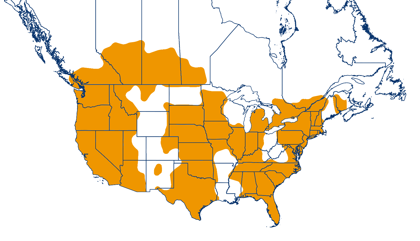
CenterPoint RTX Fast coverage available for North America
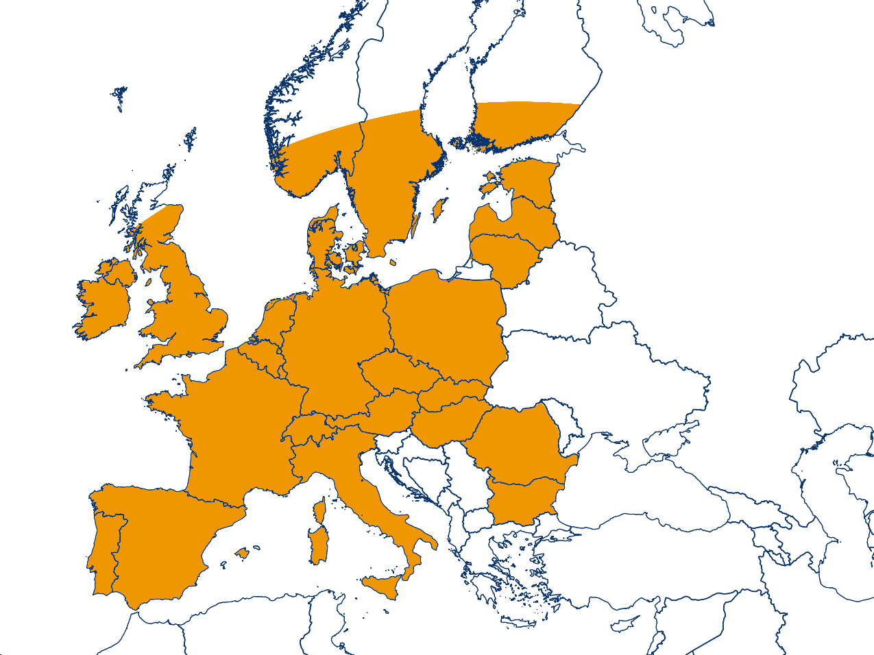
CenterPoint RTX Fast coverage available for Europe
In short, the POSPac PP-RTX service with POSPac UAV generates a centimeter-level position and orientation solution for Direct Georeferencing without: the need to wait for CORS, or the hefty costs associated with setting up a physical GNSS reference station. And in PP-RTX Fast convergence regions, these solutions can achieve high performance for even the shortest of survey and mapping missions. The resulting reduction in operation costs makes it increasingly more feasible to use UAVs for surveying and mapping purposes, thereby elevating UAV aerial survey and mapping to the next plateau.
Exactly How Accurate is Post-Processed CenterPoint RTX?
Want a thorough analysis reviewing the effectiveness of Applanix' POSPac UAV software when integrated with Trimble's Post-Processed CenterPoint RTX Fast (PP-RTX Fast) positioning technology? Download this white paper for an accuracy assessment featuring a payload comprised of the Trimble APX-15 EI UAV and Sony a7R camera on a DJI M600 drone.