
When it comes to aerial mapping from crewed aircraft, precision, efficiency and ease of use are paramount. From capturing topographical data for urban planning and infrastructure management to monitoring agricultural land to disaster relief efforts, the ability to quickly map areas is crucial work that calls for exacting methods and intuitive software anyone can use.
As demand for precision aerial mapping solutions grows, the complexity of traditional practices are falling away due to wasted time, excess cost, frustration for operators and questionable accuracy. This is where the latest advancements in blended sensor fusion come into play — offering ease of use, and a seamless blend of exacting GNSS positioning and inertial power that eliminates obsolete setup and steps.
Simplifying the complex process of crewed aerial mapping
The journey from takeoff to map creation encompasses not only the physical maneuvering through diverse terrain but also the meticulous gathering of precise data when there’s little room for error. These inaccuracies not only detract from the mission’s success but can lead to time-intensive and costly re-mapping initiatives. Aerial mapping stakes are high, elevating the pressure to deliver flawless results.
The embrace of multi-constellation GNSS marks a significant leap forward in refining the precision of aerial mapping endeavors. Capitalizing on the collective strength of all available satellites fortifies the reliability of mapping data, embedding a layer of consistency across varying terrains and atmospheric conditions — mitigating the risk of signal degradation for more reliable data.
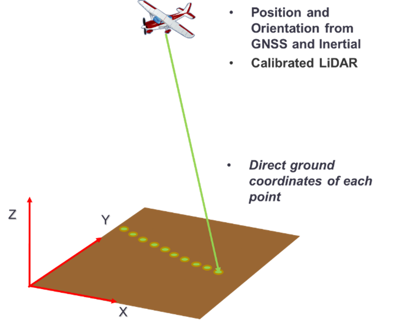
GNSS-INS synergy is transforming aerial mapping
In the quest for flawless aerial mapping outcomes, direct georeferencing proves a pivotal ally. By supplementing GNSS with IMUs and GNSS corrections, it becomes possible to measure motion, attitude and orientation with remarkable precision. This cushions the impact of environmental disturbances and in-flight dynamics that can skew data accuracy. By harnessing advanced aerial LiDAR sensors, inertial systems ensure that every data point lands solid — enabling aerial mapping with confidence.
This innovative amalgamation known as sensor fusion ushers in a new era of swift precision, providing a game-changing level of detail and reliability, while reducing the time from data capture to actionable insights.
The boundless benefits of direct georeferencing
Airborne mapping can be expensive. The cost of establishing ground control points (GCPs) alone can be prohibitive — not to mention the cost of running an airplane. Trimble Applanix systems use direct georeferencing to reduce or completely eliminate the need for GCPs, and fly projects more efficiently with less sidelap — reducing costs and environmental impact.
In earlier days, aerial mapping required setting up a base station and flying a certain distance from it. Once CORS networks came along, there was a waiting period of up to 24 hours to get that data, then more time to ensure base station coordinates were in the right datums — delaying GNSS post processing. Now with Trimble’s real-time CenterPoint® RTX and Applanix post-processed CenterPoint RTX correction services, that’s all history, creating a solution without the wait in a single datum — providing centimeter accuracy in the absolute sense.
Like dumping excess baggage
Beyond accuracy and ease of use, leveraging direct georeferencing with CenterPoint RTX in real-time or GNSS post-processing for crewed aircraft is the new standard — thanks to efficiency gains that enable users to map large areas without a base station, infrastructure or GCPs.
Direct georeferencing results mitigate needing an aerotriangulation (AT) in orthophoto generation and mosaicing. It ensures high-altitude LiDAR point cloud collections are consistent and accurate pass to pass, day to day, which can even be immediately georeferenced in the air during collection. It revolutionizes the GNSS-INS post-processing in POSPac for precision aerial mapping at the touch of a button.
Accuracy, efficiency and ease of use are paramount
We embed GNSS and IMU hardware inside the LiDAR and cameras, which collect point-clouds and images during flight. By accurately measuring sensor position and orientation during movement, each pixel, range and point is assigned a geographical location, enabling 3D reconstruction. The accurate positioning and orientation is determined by combining high rate measurements from the GNSS, IMU and CenterPoint RTX corrections services.
- Tightly integrating GNSS with inertial tech, Applanix hardware & software solutions enable greater accuracy & efficiency
- Industry-best GNSS post-processing software for direct georeferencing of airborne sensor data complements our GNSS-aided inertial tech with CenterPoint RTX — no GCPs or base station needed
- GNSS signals from all available constellations improve measurement availability and redundancy to better counteract any impact by multipath, signal diffractions or environmental obstructions
The efficiency boost that today’s clients expect
Given its undeniable efficiencies, the question is no longer if it makes sense to leverage CenterPoint RTX correction technology for crewed aerial mapping, but rather if you can afford NOT to. Between automatic processing that neutralizes the need for GCPs and client expectations to get the data right the first time, reliable georeferencing solutions are a “must have” for delivering accurate airborne maps on time, and on budget.
Case studies show the superiority of sensor fusion layered with CenterPoint accuracy over more cumbersome, time-consuming alternatives — while providing the GNSS-INS precision required for image capture at higher altitudes, and the integration of AI algorithms for automatic temporal analysis.
When it comes to direct georeferencing solutions, the source matters
Creating dependable aerial mapping solutions demands a blend of tech savvy, proven solutions in-market and direct experience with OEMs. Trimble Applanix brings a wealth of knowledge, having navigated the complexities of integrating inertial technology with multi-constellation GNSS corrections services for GNSS-INS solutions that stand up to real-world applications for over 40 years. We’re about the systems and solutions that deliver the pinpoint accuracy, efficiency and ease of use that are critical to your reputation, and bottom line.
Find out more about our crewed aerial mapping solutions and how you can try them for yourself here.