The Surveying and Mapping business segment within the UAV industry continues to make innovative advancements helping UAV operators gain efficiencies and realize substantial cost savings. These innovations not only include advancements in new sensor technologies, such as with LiDAR and high-res camera systems, or with UAV platforms, which are proving to be more reliable and often able to take on longer missions due to improved battery and flying capacity, but also with supporting components, such as with GNSS Inertial solutions used for georeferencing.
In fact, today, with a Trimble Applanix GNSS Inertial system, you can achieve survey-grade accuracy without the need for Ground Control Points (GCPS) or even a Physical Base Station for corrections.
Here's how it works.
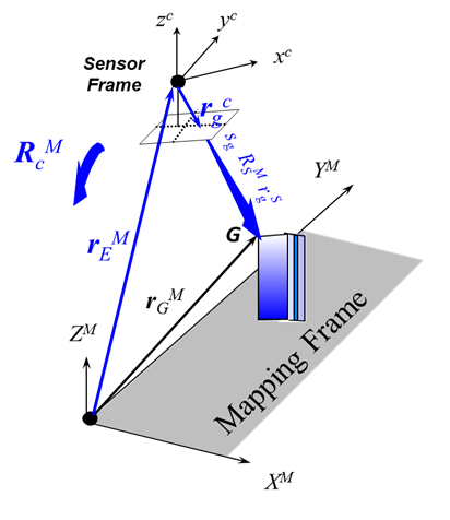
A tightly integrated GNSS/Inertial system, such as the Trimble APX-15 (pictured), can capture very accurate position and orientation data, which can be used to georeference UAV imagery without the need for GCPs. Essentially, the Trimble APX-15, or other Trimble APX board set, can tag either image pixels or points with highly accurate positioning and orientation data. This data, along with other measurable parameters, can then be used to mathematically solve the equation needed to place the geocoded data on the ground in its correct geographical location.

This process is called Applanix Direct Georeferencing and features several key advantages for UAV Surveying and Mapping. The first of these is the elimination of the need for GCPs, which are typically used in photogrammetry for tying the GCPs to corresponding locations on the imagery. The elimination of the need for GCPs provides substantial cost savings and can also provide for improved safety in those locations that may be dangerous to access. Another key benefit is the reduction in the image overlap required, this reduction is typically more than half the overlap required when using a pixel-matching method.
Applanix Direct Georeferencing, in particular, provides significant time and cost benefits when working with LiDAR scanners. The DG process, using Applanix POSPac, can tag each LiDAR point with position (GNSS) and orientation (via an IMU) values, resulting in highly accurate georeferenced point clouds. When using LiDAR for surveying and mapping missions and where both precision and accuracy are key requirements, Applanix DG becomes essential to remaining cost-competitive in an ever-growing LiDAR market.
What about the need for an augmentation (correction) solution?
Correcting the positional (i.e., GNSS data) when using Direct Georeferencing has typically involved the use of a physical base station, which requires time to set up and to start logging correction data. This too is also not needed if an over-the-air correction service is employed. For example, a Virtual Reference Station (VRS) can be used where real-time kinematic (RTK) solutions provide high-accuracy correction data. An example of this would be the use of Continuously Operating Reference Stations (CORS) networks, which provide GNSS data for three-dimensional positioning. For this, Trimble provides a solution called Applanix SmartBase. The one drawback with CORS, however, is that the correction data can take up to 24 hours to arrive, which delays post-processing work.

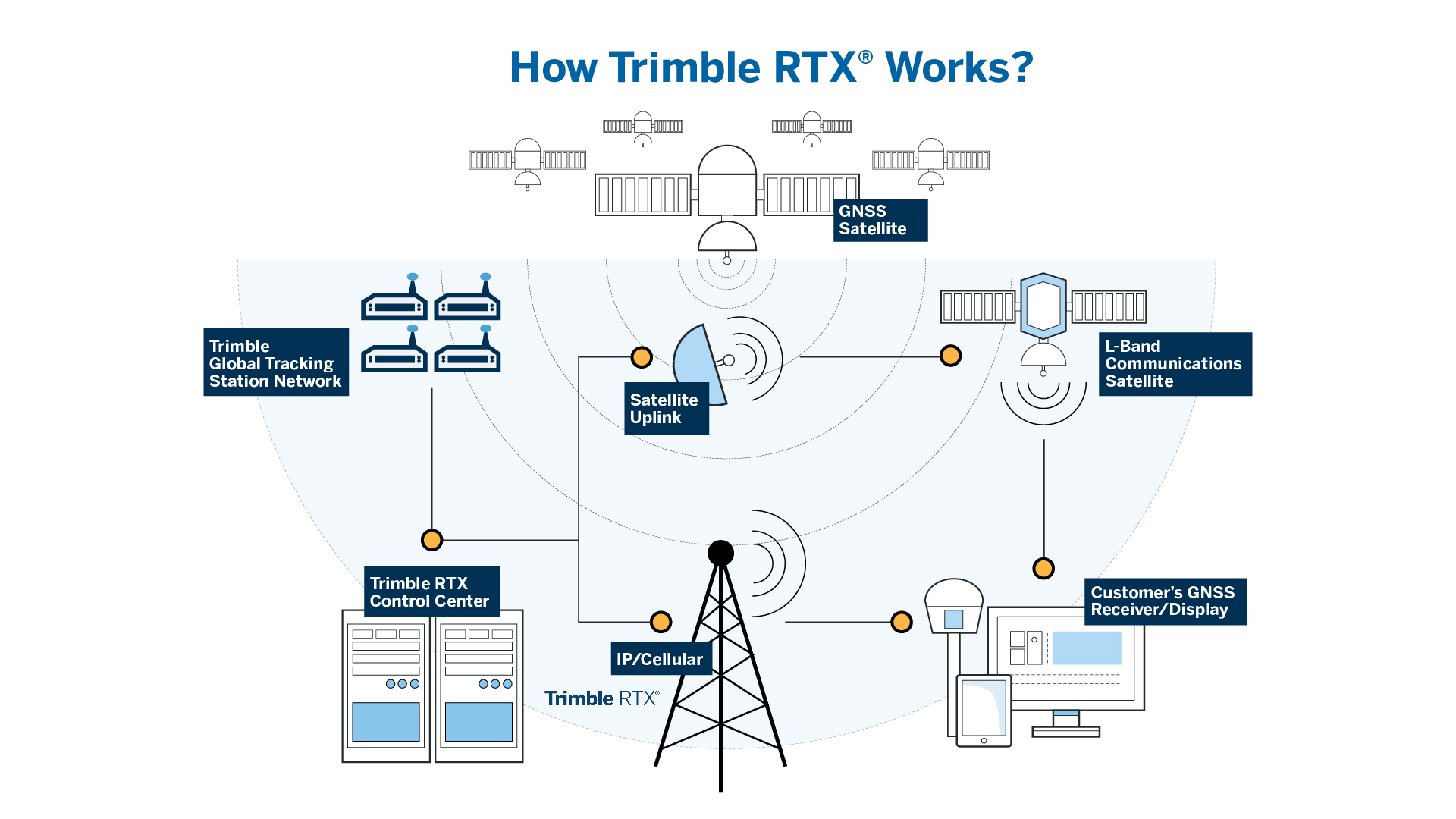
Better yet, Trimble's Applanix POSPac PP-RTX service delivers advanced precise point positioning that provides real-time centimetre-level accuracy. Applanix POSPac PP-RTX service uses the same data generated by Trimble's RTX real-time correction services (see diagram below), which models precise satellite orbit, clock and atmospheric information.
Applanix POSPac UAV uses this data to post-process the GNSS-inertial trajectory as an alternative to SingleBase, SmartBase and MultiSingleBase augmentation processing methods. You can learn more about Applanix POSPac PP-RTX here.
What are some typical use-case examples where Trimble’s Applanix POSPac PP-RTX for UAV provides a distinct advantage?
One such use case would be corridor mapping. For example, when using LiDAR to complete a corridor inspection, long trajectories are needed to provide the coverage required. The advantage of being able to eliminate the need to set up physical base stations to capture GCPs over the length of the corridor provides huge time and cost savings.
Another example would be in areas where access is formidable, and ground control via a physical base station may be difficult to acquire; using the Applanix POSPac PP-RTX service allows for corrections data to be captured over the air, while still maintaining centimetre-level accuracy.
Thus, to conclude, no GCPs and no physical Base Station is no problem for completing your UAV surveying and mapping missions with Trimble's Applanix DG!