Stantec is a multi-disciplinary organization providing innovative engineering and data gathering for a diverse group of clients with diverse needs. Utilizing an array of state-modern equipment and technology, Stantec is recognized throughout the industry for its ability to deliver sustainable, cost effective solutions.
The Challenge
The New Jersey Department of Transportation selected Stantec to undertake an extensive data-gathering project covering more than 17,000 miles of non-Federal Aid routes. The project required Stantec to cross the state, generating pavement condition survey information, together with simultaneously captured high-resolution digital video imaging. Both pavement and imaging data needed to be accurately georeferenced - no GPS outages allowed!
The Solution
Stantec's custom-designed RT3000 mobile mapping/data capture system used various sensors engineered to generate a variety of information," Rob Huber, Operations Manager, Infrastructure Management and Pavement Engineering at Stantec, explained. "We generally drive a route once and generate multiple georeferenced sets of data, which can then be analyzed by our technicians at the office. This technique works very well, particularly when using a single georeferencing source, such as the Applanix POS LV."
The Result
The RT3000 with the Applanix POS LV captured the 17,000 miles of pavement data and digital videolog imagery in less than 18 months. "Being able to utilize the POS LV system's continuous positioning ability is a real plus in areas like this. Even collecting data in urban areas presented the POS LV with little problem, where buildings often have an effect on a GPS solution," said Huber.
With the project complete, Stantec delivered the road roughness, rutting, and pavement distress data together with a set of videolog imagery all georeferenced to the states coordinate system.
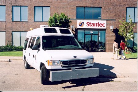
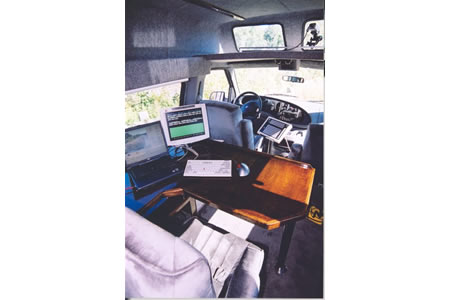
Image 1: Stantec's custom-designed RT3000 mobile mapping/data capture system
Image 2: Inside the Stantec RT-3000 is a wide array of digital capture and Georeferencing technologies