This case study describes the Post Processed Virtual Reference Station (PPVRS) technique for multibeam Marine Hydrography. This technique uses GPS network stations to determine atmospheric biases at the rover positions and tightly integrates GPS with inertial data to provide a continuous, high-precision navigation solution with baselines of up to 80 km.
The Test
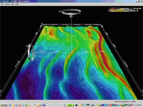
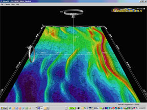
A standard NOAA hydrographic survey was chosen in the Chesapeake Bay to test the PPVRS work flow. Data acquisition was conducted aboard NOAA Ship RUDE (pronounced "Rudy") on October 18th 2007 as part of the acquisition of a multibeam reference surface. RUDE performed inshore hydrographic surveys along the east coast in support of NOAA's nautical charting mission and was equipped with some of the most technically advanced hydrographic and navigation equipment available.
On the RUDE all raw positioning sensor data was logged for post processing. GPS reference station data for the same time period was logged on-shore - no dedicated based stations were required! For this test actual CORS station data was used as provided on NOAA's National Geodetic Survey's website.
POSPac MMS was used to process the POS MV data and produce a Smoothed Best Estimate of Trajectory (SBET) file for import into Caris HIPS and SIPS, NOAA's Hydrographic Processing software.
The Result
Positional accuracies were substantially improved. The loading, dynamic draft, and tide effects were negated because the vessels vertical position was being accurately measured. The data was accurate to better than 5 cm in X, Y, and Z.
This new method, while considerably simpler, yields results equal to or slightly better than the traditional method.
The Conclusion
The PPVRS process provides a logistically simple method, when compared with the traditional IAKAR mechanization, for achieving centimetric-level accuracy without installing and maintaining dedicated base stations. The overall process is simple and can be easily added to existing hydrographic data processing workflows without a significant decrease in processing productivity. The gains from the increased accuracies far outweigh the small amount of time required to process the data. It is expected that survey companies will realize significant efficiency gains with PPVRS.
Applanix SmartBaseTM, within Applani' POSPac MMS software, utilizes PPVRS and tightly coupled IAPPK techniques for marine hydrography and offers the best solution for marine hydrographic surveying.