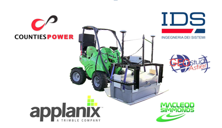
Counties Power and the award winning "PAL-GPR System"
About Counties Power: Serving the southern edge of Greater Auckland in New Zealand, an area known as Franklin, Counties Power Ltd (www.countiespower.com) has been delivering electricity since 1925. Today it has 3400 kms of network lines serving approximately 35,000 customers.
Counties Power is also bringing ultra-fast fibre broadband internet access to Franklin. A fibre optic network is in place serving the nearby Pokeno, Papakura and Pukekohe areas. Working with retail ISPs, high speed internet service is being supplied to the area, operating at speeds of up to 10,000 Mbps for both sending and receiving data.
The Challenge
Counties Power identified a strong need to create a sub-surface map of existing utility infrastructure ahead of new construction. Locating and identifying services is important to all underground construction teams. Without this, drilling activities could cause serious damage to critical infrastructure and lead to costly and time-consuming repairs.
While "as-built" plans of existing subterranean infrastructure do exist, experience shows they cannot be relied on to be up to date and geographically correct. Any drilling activity is therefore very risky and potentially dangerous and costly.
Counties Power recognized that their own construction teams needed more reliable information when working around new power and optical fibre network. They also identified an industry need for an underground utility location system to assist construction teams and asset managers
The Solution: A World-First in Array GPR Technology
In the early stages of developing the PAL-GPR System, Counties Power tried using single channel radar systems together with Radio Frequency Locators (RFLs) to scan and reveal underground infrastructure. This proved to be only partially effective. While the RFL's detected metallic underground items, non-metallic items such as water pipes and optical fibres were not always revealed and there was a dependence on the Operators skills. A solution that could quickly survey, identify and geo-reference all possible types of underground infrastructure was needed.
The resulting array Ground Penetrating Radar (GPR) system developed by Counties Power is the first in the world to offer the total package of features needed for utility location:
- High definition and resolution for reliable asset identification, with very accurate location sensing, delivering results to within 1 cm spatial resolution.
- Motorized GPR locating in the road and the berm using the same platform, in a safe transport system for rapid data capture on and off-road.
- Classification of utilities to international standards (draft AS/NZ 5488, US and British) that is delivered into CAD and GIS systems in a timely manner, and visualized using Augmented Reality.
A Technical Innovation
This innovation overcomes some weaknesses of existing technologies using innovative components:
- Counties Power acquired a pre-commercial array radar from leading manufacturer IDS (Italy) through their partner GeoStudi Astier. This delivers increased definition through its particular combination of 24 radar channels, 600 MHz and 2 offset linear arrays, with spatial resolution of 4 cm.
- Enhanced location sensing was achieved using a differential GPS system closely coupled with a POS LV by Applanix and Trimble VRS to deliver location accuracy to 1 cm. POS LV is a compact, fully integrated, turnkey position and orientation system, utilizing integrated inertial technology to generate stable, reliable and repeatable positioning solutions for land-based vehicle applications. It is designed to operate under the most difficult GPS conditions found in urban and suburban environments and is proven technology for providing accurate geo-referencing for road geometry, pavement inspection, GIS database and asset management, road surveying, and vehicle dynamics.
- The transport system for the unit is a compact tractor by Avant (Finland) which performs well on and off road. It has custom fitments to protect the on-board instruments and maximize the unit's capability and productivity. Counties Power understands this is the first motorized GPR device in the world suited to use on the road and the berm.
- Captured data is processed using a specialist GPR-CAD system for utility identification, with expert analysis by Macleod Simmonds in the UK. Outputs are compatible with CAD and GIS for easy update of asset records. Achieving this involved extensive software development.
A Commercial Innovation with Many Benefits
The multi award winning system is referred to as the PAL-GPR System. PAL stands for Precision All-terrain Location and 'System' reminds users the technology includes both the advanced GPR unit and the system of analysis and delivery of outputs into CAD and GIS that set it apart.
 |
To learn more about Counties Power, visit www.countiespower.com |
|
The PAL-GPR System lowers project risks. It delivers on its early promise to be an effective, non-invasive and commercially viable utility location system. For Counties Power that means lower strike rates, greater safety, higher productivity, greater reliability of supply and better records. The managers of other utilities are interested and the system promises to set new standards in engineering practices for the location of underground utilities. |
|