Benefits
- Increased efficiency: reduction in cost and time
- High-performance accuracy
- Reliability
- Reduction in risk
Overview
- GSI to survey all of Ireland’s nearshore coastal waters
- Update mapping – existing data over 100 years old
- Extensive, 20-year project had inefficient workflow
- Single base system lacked remote access, incurred performance interruptions
- CORS network less accurate, required more processing effort
ABOUT GSI
Founded in 1854 as Ireland’s earth science knowledge centre, Geological Survey Ireland (GSI) is responsible for providing Ireland’s public and private stakeholders – and the international community – with free, open and accurate data and maps of the country’s subsurface topography. A division of The Government of Ireland’s Department of Communications, Climate Action and Environment, GSI’s expertise is crucial to understanding the country’s underground terrain in relation to a wide spectrum of topics, including: bedrock, groundwater, seabed mapping, natural disasters, and public health risks.
NEED
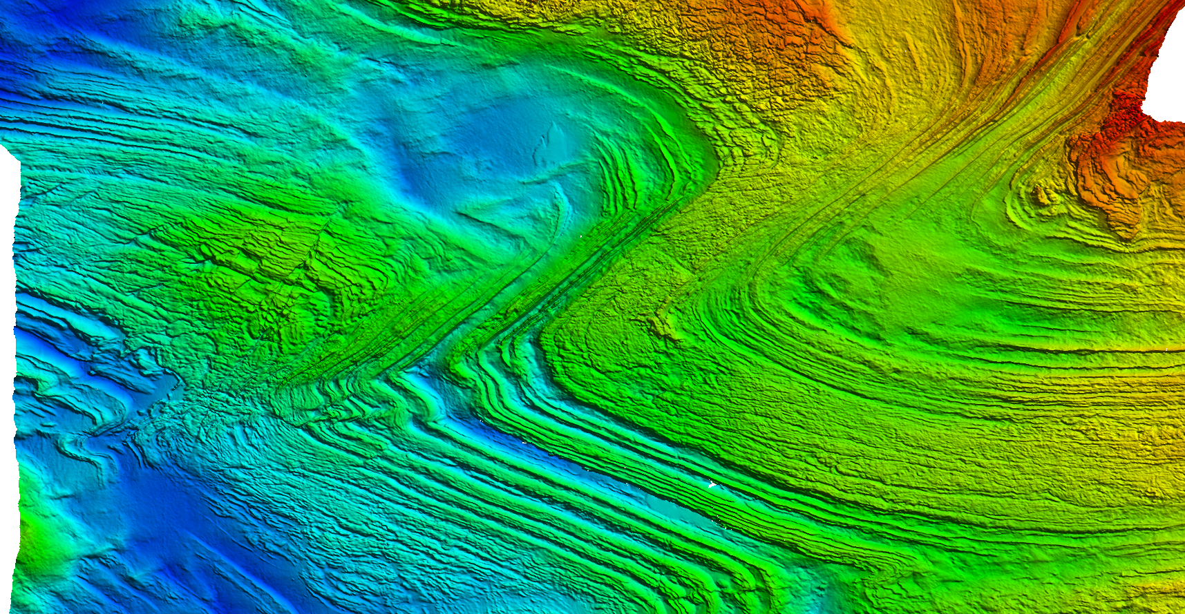
The need arose for a thorough mapping of the country’s coastal sea floors in order to update historic sea floor data collected in the 1800’s. Existing surveys were produced with obsolete technology and provided limited seabed information. They inhibited future growth, and were in significant need of revision to bring them up to modern standards. Working in partnership with the Irish Marine Institute, GSI undertook mapping all of Ireland’s nearshore coastal waters; high accuracy and modern data is required to promote the development of offshore resources using more efficient and sustainable methods.
CHALLENGE
The challenge GSI faced was not insignificant: the mapping program, which began in 2006, was projected to take 20 years to execute. The act of data collection was extensive in itself, with multiple missions ranging from as little as 2 days to as many as 50 days at sea. Established workflows were reviewed and scope for efficiency improvements were identified. Using a Single Base with POSPac MMS required numerous trips to the local station to retrieve data, as there was no remote access. In addition, this method suffered from frequent performance interruptions due to instrument failure, power loss, and logging errors.
Conversely, using the publicly-accessed CORS network created other difficulties: relying on stations that were farther away produced less accurate results and required greater processing effort.

SOLUTION
Investigations were already underway to assess the benefit of incorporating a realtime centimeter level correction service when GSI heard about Applanix’ PP RTX with POSPac MMS 8 solutions, and seized the opportunity. POSPac 8, with Trimble CenterPoint RTX, is Applanix’ industry-leading software for Direct Georeferencing of mobile mapping sensors using GNSS and inertial technology. Optimized for all environments and platforms (air, land, and marine), and compatible with a variety of mapping sensors, this smart software solution achieves both maximum accuracy and maximum efficiency.
The system’s flexibility to thoroughly test and control the transformation settings removed many of the hardware- and software-related variances.
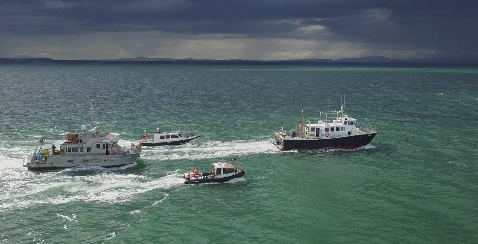
In 2017, GSI deployed 4 inshore survey vessels armed with POSPac 8 and CentrePoint RTX to map the continental shelf and inland waters at a depth of 0 – 120 metres, for a total of 217 days at sea.
RESULTS
The PP RTX with POSPac MMS 8 boasted a dramatic increase in efficiency, achieving 100% up-time and uninterrupted usability, with no installation or maintenance of a local base station required. All data processing was completed within 90 minutes of coming ashore, with no added commitment to re-process for better results. Ultimately, the entire operation saw at least a 50% reduction of effort in navigation processing – significantly reducing GSI’s labour, while still retaining optimal quality results.
Achieving high accuracy with any mobile survey vessel is difficult, but the PP RTX attained comparable results to the single base station, performing well within GSI’s required parameters. Any minor loss in fidelity was immediately offset by the extensive gains in user accessibility.
Aside from the conspicuous absence of disturbances and maintenance issues, the PP RTX with POSPac MMS 8 also proved to be a reliable post-processing tool in terms of controlling geodetic transformations – a simple conversion process that, if mishandled, can have adverse effects. The system’s flexibility to thoroughly test and control the transformation settings removed many of the hardware- and software-related variances.
Yet perhaps the most significant benefit to GSI was the reduction in risk profile. Local base stations generally required non-obstructed access, and would therefore be mounted atop roofs or high places, posing a risk to crew during routine installation and maintenance. GSI’s switch to Applanix’ PP RTX has completely removed this line item from their risk register, successfully securing a safer work environment for all involved. And for GSI, the safety of their surveying teams who must weather all of nature’s elements is of the utmost importance.
The tide has turned for Geological Survey Ireland with their adoption of Applanix’ PP RTX with POSPac MMS 8: not only has GSI significantly improved workflow efficiency while maintaining a high degree of accuracy, but they have found a safe and reliable asset in their ongoing mission to redefine the hydrographic landscape of Ireland’s shores.
"Our team has been very happy with Applanix' products and support for the past 9 years. The hardware, documentaiton and customer support are excellent. Applanix provides a well-designed, comprehensive solution."
–– David Hardy, Geologist, Geological Survey Ireland
Highlights
- Dramatically increased efficiency: 100% uptime, reduced labour significantly
- Delivered high-performance accuracy
- Post-process software proved valuable to eliminate variances, increase reliability
- Reduced risk profile